

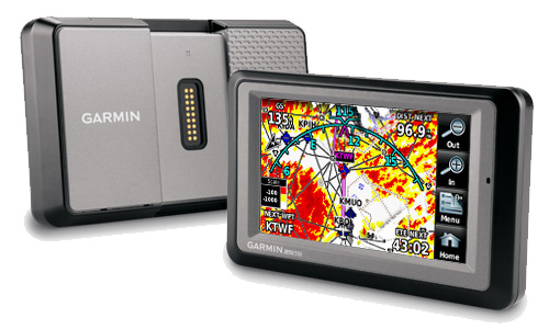
GARMIN AERA 550 ATLANTIC
Part# 11-08051
1,483.57$ + IVA
Overview
 |
||||||||||
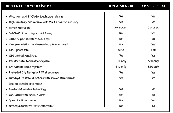
| Leveraging Garmin’s industry-leading expertise in both Aviation and Automotive GPS, the versatile aera series of touchscreen portables take fingertip navigation to a whole new level. Featuring crisp 4.3-inch QVGA wide-format displays, all four aera models come with preloaded automotive maps, a built-in terrain/obstacles aviation database, patented Panel Page instrument display, and more. So, wherever you fly or drive, you can count on aera to provide the complete door-to-door guidance package. | ||||||||||
 |
The aera 550: A Premium Choice Elevate Your Expectations Attention Road Warriors Garmin aera series: It’s the ultimate fly/drive option. ¹Navteq traffic alerts require the GTM 20 (sold separately). Traffic content not available for all areas. See www.navteq.com/rdstraffic for traffic coverage areas. Inthe box:
|
|||||||||
|
||||||||||
 |
||||||||||
 |
||||||||||
 |
||||||||||
 |
||||||||||
![]()
Features
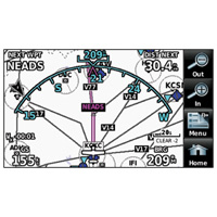
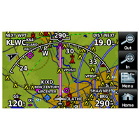
- Moving map: yes
- HSI (GPS-based): yes
- IFR map mode: yes
- Traffic Information Services (TIS) alerts compatible: yes
- Audible terrain alerts: yes
- Terrain resolution: high
- Smart Airspace Feature (generates and displays altitude-sensitive alerts): yes
- Automatic logbook: yes
- Separate serial and USB interfaces: yes
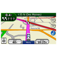
- Voice prompts (e.g. “Turn right in 500 ft.”): yes (auto mode)
- Speaks street names (e.g. “Turn right ON ELM STREET in 500 ft.”): yes (auto mode)
- Lane assist (guides you to the proper lane for navigation): yes (auto mode)
- 3-D map view: yes (auto mode)
- Bluetooth® wireless technology: yes (auto mode)
- Speed limit indicator (displays speed limit for most major roads in the U.S. and Europe): yes (auto mode)
- FM traffic compatible: yes (auto mode)
- Custom POIs (ability to add additional points of interest): yes (auto mode)
- XM WX Weather & Radio for U.S. & Canada compatible: no
Specifications
- Unit dimensions, WxHxD: 5.3″W x 3.3″H x .9″D (13.5 x 8.4 x 2.3 cm)
- Display size, WxH: 3.81″W x 2.25″H (9.7 x 5.7 cm); 4.3″ diag (10.9 cm)
- Display resolution, WxH: 480 x 272 pixels
- Display type: touchscreen WQVGA color TFT with white backlight
- Weight: 9.5 ounces (270 g)
- Battery: removable, rechargeable lithium-ion
- Battery life: up to 5 hours (less with full backlight and options)
- Waterproof: yes (IPX7)
- Voltage range: 11-35
- Receiver: high-sensitivity with WAAS position accuracy
- IFR or VFR: VFR
- Basemap: yes
- Navigation database (includes Jeppesen® data): yes
- Types of Jeppesen data: full and ARTCC, FSS frequencies and final approach waypoints
- Navigation database coverage areas: Atlantic
- Preloaded Obstacles database: yes (U.S. and Europe only)
- Preloaded AOPA Airport Directory: yes (U.S. only)
- Preloaded Garmin FliteCharts®: no
- Preloaded low & high altitude enroute airways: yes
- Preloaded street maps: yes
- Ability to add maps: yes
- Accepts data cards: yes (microSD™ cards)
- Built-in memory: internal solid state
- Waypoints/favorites/locations: 3,000 (aviation mode); 1,000 (automotive mode)
- Routes: 50
