
GARMIN GTN 625 GPS SYSTEM USA BLACK FACEPLATE G3X REQUIRED
Part# 11-14424
10,981.63$ + IVA
Overview
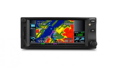
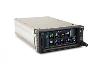
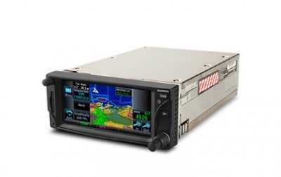
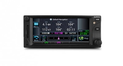
GTN 625 is a 2.64-inch standalone GPS navigator that puts high-resolution terrain mapping, graphical flight planning, advanced navigation, multiple weather options, connectivity and traffic display right at your fingertips. Touch and GoWith its revolutionary touchscreen interface, GTN 625 puts primary functions just a few taps away. Pan across the map screen by swiping your finger across the 4.9-inch high-resolution TFT display, and enter waypoint data with the onscreen alphanumeric entry. There are multiple ways to reach information and lots of shortcuts built right in. The data displayed can easily be customized to instantly reach any page in the system right from the moving map or navigation pages — so it’s easy to fly with the information that’s most important to you. Raised grips in the bezel and a shelf across the lower edge of the display serve as gripping points in both smooth and turbulent flight conditions. Traditional concentric knobs are also available for data input. If youhave a GNS 430W/530W, active flight plans automatically crossfill from the GTN to the GNS, or just manually crossfill user waypoints between devices. Navigate with EaseThe GTN family makes it easier than ever to get where you’re going. Graphical flight planning capabilities allow you to edit your entire route using the map screen and easily enter new waypoints or modify existing ones. A handy “rubber band” feature lets you grab any leg of your flight plan route and move it to accommodate a deviation or ATC amendment to your flight plan. The GTN 625 also allows you to enter your most recently visited or nearest airports as waypoints and “Direct To” destinations. Execute Precision ApproachesThe system’s robust 15-channel GPS receiver generates five position updates per second. This SBAS/WAAS-certified technology allows you to fly GPS-guided LPV glidepath instrument approaches down to as low as 200 ft. In addition, precise course deviation and roll steering outputs can be coupled to select autopilots so that IFR flight procedures may be flown automatically. This includes all ARINC 424 leg types, except RF legs. (For example, when coupled with a G500/G600 Flight Display, the aircraft can fly fully coupled missed approaches, including heading legs.) See More Than Ever BeforePacked full of multifunction display capabilities, the GTN 625 brings enhanced situational awareness to your cockpit. With high-resolution terrain mapping – including topography features, cities, airports, terminal areas, SUAs and more – and optional Class B TAWS alerting, you’ll find your way around the airspace safely and with ease. The system even allows you to load and follow Victor and jet airways. On the ground, built-in Garmin SafeTaxi® U.S. airport diagrams give you geo-referenced runways, taxiways, FBOs and hangars. Couple the system with a GDL 69 series datalink receiver and XM® subscriptions, you can overlay NEXRAD radar right onto your moving map display and receive satellite music. Or add a Garmin traffic system and pinpoint other aircraft in your vicinity. The GTN 625 can control the GTX 32/33 remote transponder, which could also save you valuable panel space. Stay Up to DateThe GTN 625 features a front-loading SD™ card reader, so you can easily update your databases. PilotPak™ database bundles are now available on a single aircraft basis, saving you money and simplifying the update process. |
Features
- Menu-driven graphical interface on color LCD touchscreen display
- Feature-rich MFD capabilities: moving map, airways, approaches and more
- GPS TSO’d to C146c, authorized for Class 1,2,3 (LPV)
- GPS WAAS-certified to Gamma-3 approach capability
- WAAS-corrected GPS signal accuracy to 1 M RMS
- Graphical flight planning (including airway navigation)
- Extensive optional interface capabilities: lightning, weather, traffic, TAWS-A and B terrain alerting
- Integrated control/display for remote transponder
- Flight control system interface for select autopilots
- Optional SiriuxXM Satellite Weather and Radio
- SafeTaxi® airport diagrams
- Award-winning product support and 2-year warranty
Specifications
Physical & Performance
| Physical dimensions: | 6.25”W x 2.65”H x 11.25”D (15.9 x 6.7 x 28.6 cm) |
| Display size, WxH: | 4.46”W x 1.98”H (11.33 x 5.02 cm); 4.9” diag (12.4 cm) |
| Display resolution, WxH: | 600 x 266 pixels, 600 x 266 pixels |
| Display type : | Color TFT LCD; sunlight readable |
| Weight : | 5.4 lb (2.48 kg) |
| SBAS/WAAS receiver : | 15 channel; TSO-C146c |
| SiriusXM™ Weather & Radio compatible: | Yes |
| Voltage range: | 11-33 |
| Transmit power: | no (VHF comm not included) |
| IFR or VFR: | IFR |
| Traffic Information Services (TIS) alerts compatible: |
Yes |
Maps & Memory
| Basemap: | Yes |
| Waypoints/favorites/locations: | 1000 |
Databases
| Navigation database coverage areas: | Americas, International or Worldwide* |
| Preloaded Terrain database: | Yes |
| Preloaded Obstacle database: | Yes |
| Preloaded SafeTaxi™ airport diagrams: | Yes |
| Preloaded Garmin FliteCharts®: | Not available |
| Flight plans: | 99 reversible; up to 100 waypoints each |
GPS/Nav/Comm Features
| Fly SBAS/WAAS approaches: | Yes |
| Front-loading datacards (conveniently update database information): |
Yes |
| Class B TAWS alerting compatible: | Yes |
Additional
| Additional | Warranty: 2 years |
| Databases: | |
| Eligible for PilotPak databases. | |
| Databases included: worldwide basemap, worldwide obstacles, worldwide terrain, region-specific NavData, SafeTaxi, Airport Directory | |
| GPS receiver has a nominal operating velocity range of | |
| 0 – 800 kts (411 m/s) |
Documents
In The Box
- GTN 625
- Cleaning cloth
- Installation kit
- Simulation software DVD
- Familiarization video DVD
- Pilot’s guide
- Cockpit reference guide
- Complimentary database update certificate
